Written by Doug Crouch
Assessment Phase: Quick Summary
4. Holistic Site Analysis Checklist – the client/ land interview with an analytical perspective.
Decipher or interpret needs of the client and gain insight into the site’s context from the assigned sheet. Use it to help catalogue observations and research. Not every bullet will be used.
5. Observation then Interpretation – Protracted & Thoughtful Observation leads to site assessment.
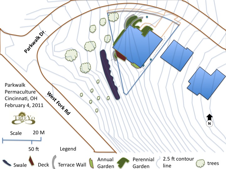
Create a Base Map – include names, date, north indicator, location, key, scale, and anything that cannot be changed.
Sector Analysis Overlay – map wild energies such as sun, wind, pollution, etc.
6. Analysis of Flow – Visually represent how energies such as water, traffic and wildlife move through the landscape. This differs from the sector analysis, remember the restaurant example.
Analysis of Flow Overlay – map water flow, traffic flow, wildlife, and/or frost. Use arrows of different colors and thickness to delineate energy flow and its intensity. Remember to have a key. Make notes of any microclimates or unique features using words and bubbles. The Analysis of Flow can be combined with the Sector Analysis on the same overlay if appropriate. These will help with your introduction for the design presentations.
7. Community Vision- Bringing life to the social dynamic/ vision of the community. Use description and elements of a community vision. Define vision, mission/purpose, values, Interests, Goals/objectives, Aspirations, and Strategy. Remember to dress why, how, and what to bring vision further.
This written doc is a major part of the introduction.
Assessment Phase: Detailed Description and Examples
4. Holistic Site Analysis Checklist – the client/ land interview with an analytical perspective.
Decipher or interpret needs of the client and gain insight into the site’s context from the assigned sheet. Use it to help catalogue observations and research. Not every bullet will be used.
Headers include:
- CLIENT PROFILE
- CLIENT NEEDS
- SITE OVERVIEW
- ENVIRONMENTAL ANALYSIS
- SOCIAL SYSTEMS
To access the whole sheet click here please: Holistic Site Analysis
This sheet is meant to give you guidelines for how the constant analysis process is done. Keep it handy cause many things will come up as you move through all phases. It will guide observations and questions.
5. Observation then Interpretation – Protracted and thoughtful initial observation leads to site assessment.
- Base Map which includes- Names, date, north indicator, location, key, scale, and anything that can’t be changed. Remember that Google Maps and GIS systems are a huge help. Base maps show what is there now so the client can see the before and after process. When using a computer simply draw over what you see from gathered google earth or GIS photo and on site observations as some pictures maybe outdated. If doing it on paper you can use a projector to shine the image to a state where you can trace over. Remember that when you do your initial screen shot you should make sure the scale is included so that it can always be transferred. Google Maps has a 45 degree option that is great for seeing the sites but is not good for making maps so make sure you have the right angle from above. Also BING sometimes has more updated and clearer maps and sometimes I use a couple of different pieces of map sources (GIS, Google, BING) in combination to produce a base map. I personally use PowerPoint for generating design maps and if you would like to read the following article please click here:
- Doug Crouch on How to Use PowerPoint as a Design Tool
- Sector analysis- mapping of wild energies (in the form of an overlay with the following analysis of flows)
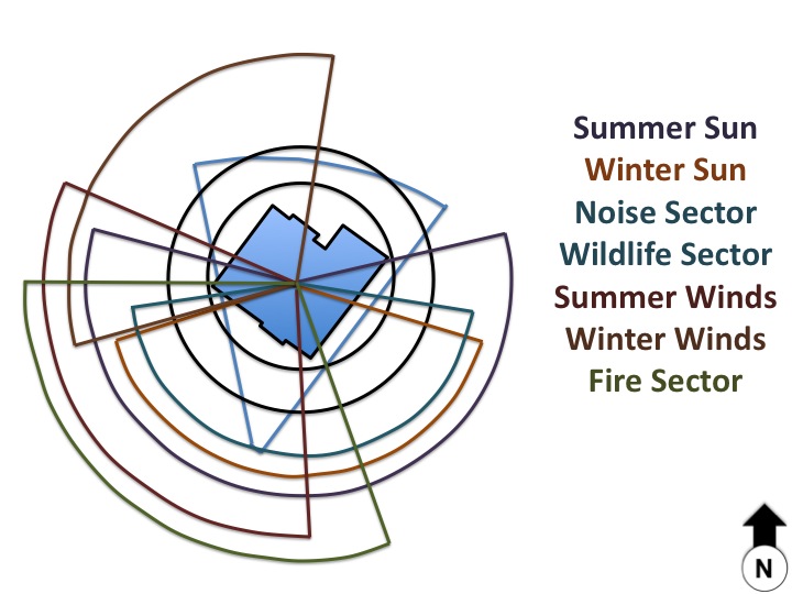
Sector analysis
From there you will be using a sector analysis to map the wild energies of the site that are passing though. Focus on summer and winter sun, summer and winter wind, noise, wildlife, and fire. You may also have a pollution factor or another site pertinent factor like floods. To review sectors within the context of Energy Efficient Planning click here.
Remember to block, channel, or open up sector or use a combo to deal with these wild energies that can be a plus or minus on any site. Turn problems into solutions.
6. Analysis of Flow – Visually represent how energies such as water, traffic and wildlife move through the landscape. This differs from the sector analysis, remember the restaurant example.
- Analysis of Flow Overlay – map water flow, traffic flow, wildlife, and/or frost. Use arrows of different colors and thickness to delineate energy flow and its intensity. Remember to have a key. Make notes of any microclimates or unique features using words and bubbles. The Analysis of Flow can be combined with the Sector Analysis on the same overlay if appropriate. These will help with your introduction for the design presentations.

The flow analysis is an enlightening process to understand flows of energy and shows how they can be improved, accentuated, or completely altered. I tend to map water, human traffic, wildlife traffic, nutrient flow, and frost (if applicable). Use arrows of different colors and thickness to delineate energy flow. For example as water flows come to together from a roof and the valley in a landscape, the lines should be drawn thicker. This helps to determine where to collect rainwater and the design feature earthworks that would help to sink it into the ground. From this we recollect our principle of energy cycling (Source to sink) and harvest water higher in the landscape before water accumulates into torrents which would require heavy earthmoving equipment. Remember that the flows are to have a key. The overlays can happen individually on a computer or done together on tracing paper. Each member could take on one of the flows or this could be accomplished in the group. You can use words to highlight certain features like concentrations from a roof and then make interpretations like possible rain garden site or swale or roof catchment tank.
- Community Vision- Bringing life to the social dynamic/ vision of the community. Use description and elements of a community vision. Define vision, mission/purpose, values, Interests, Goals/objectives, Aspirations, and Strategy. Remember to dress why, how, and what to bring vision further.
This written doc is a major part of the introduction.
Before moving on to generating ideas of land development an overall articulation of the vision must occur. It will give you insights into the community glue which will meet social and environmental factors into a holistic vision. Use assessment from the client interview and go back to the why, how and what if you need to dialogue further with the client or within your design group.
